Industry Experts

We work with institutions, local governments, and companies operating in key areas of environmental and spatial management. We provide technological solutions that truly improve everyday work—in the field, in the office, and at the decision-making stage.

We understand the specifics of every industry in which we operate. We know the challenges our customers face and what data they need to operate effectively, on time, and in compliance with regulations. We design our systems to integrate information, automate processes, and support accurate decision-making. Find out how we can help you!
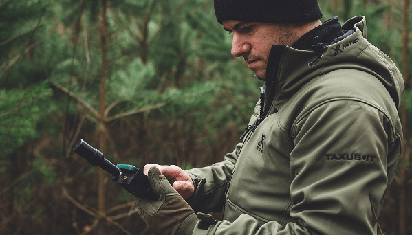
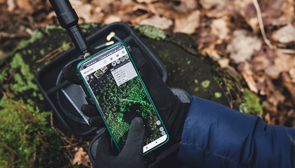
FORESTRY

TAXUS IT forestry expertise – from land surveying to digital management planning.

Forest management using spatial and operational data

The TAXUS IT team has been specializing in a systematic approach to forest management for years, combining knowledge in the fields of geoinformation, resource management, and spatial planning. The solutions we create enable the documentation of forestry work, resource inventory, and data synchronization with central systems.

5 data sources

analyzed together: drone, satellite, GPS, sketch, measurements
Our systems are used by as many as

16 000

LP and PN users

Reduce time for measuring stocking levels and planning cuts thanks to digital relascopes

Our forest management and field measurement specialists have implemented digital relascope measurements, which speed up the estimation of resource abundance and cutting intensity. Thanks to the automation of calculations, it is possible to plan maintenance measures without the need for manual calculations and with immediate data visualization.
Full measurement + cut intensity in less than

10 minutes

Compliance

with IUL, IBL boards, and LP documentation

Automation of drone photo and satellite image processing

The TAXUS IT team of environmental analysts creates orthophotomaps and tree stand health analyses based on data from drones and Sentinel-2 satellites. Our solutions enable the detection of changes in forest structure, damage monitoring, and the generation of point clouds for 3D analysis.
New Sentinel-2 data every

30 days

– RGB, CIR, NDVI
up to

40 GB

of orthophoto map data stored in the cloud

Precise field measurements in difficult conditions thanks to specialized receivers

TAXUS IT engineers have developed positioning equipment and algorithms adapted to the specific conditions of working in dense forests and varied terrain. Our solutions provide stable GPS measurements even where standard receivers lose signal.
Accuracy:

<1 m

even with canopy density >80%

No configuration required

– ready to use in seconds

Full data compatibility with State Forest (LP) systems

Our data integration specialists ensure that the information we generate is fully compatible with LP systems: LIMES, BDL, Szkicownik Leśniczego (Forester’s Sketchbook) and Przeglądarka LMN (LMN Viewer). We support file structures, export formats, and communication protocols that comply with institutional requirements.

Export of assessments and drafts

directly to tools used by LP.

Data loading
by WMS in QGIS, LIMES
and LMN Viewer

Smooth data flow between the field team and the office

Thanks to the synchronization models we have developed, data collected in the field is immediately available to planning teams. We eliminate downtime, manual transfer errors, and decision delays, supporting the digital flow of information within LP units.
Verification of hunting damage

up to 3 x faster

than traditional methods
Data transfer time:

<10 seconds

NATURE CONSERVATION

TAXUS IT's environmental expertise – from inventory to project audit.

Support in conducting nature inventories (flora, fauna, habitats)

The TAXUS IT team specializes in designing solutions for documenting natural elements in the field – in accordance with the guidelines of the General Directorate for Environmental Protection and the EU habitat classification. By combining biological knowledge and mobile technologies, we develop systems that enable data recording with GPS accuracy, assignment of descriptive and visual attributes, as well as preparation for further environmental analysis.

1 tool = GPS data,

species descriptions, and photo documentation 
– field registration

Over 200

types of habitats and species in accordance with the EU classification

Monitoring environmental changes based on satellite images and drone data

Our specialists create systems that enable the detection of changes in land cover structure and habitat condition based on cyclical Sentinel-2 data and drone footage. This allows us to track the progress of conservation measures, the effects of drought, anthropogenic pressure, and natural succession over a long time horizon.

New data every 30 days

– Sentinel-2 with 10 m resolution 
(NDVI, RGB, CIR)
Habitat changes analyzed over a period of

up to 3 years

– historical data in the system

Construction of integrated databases – descriptive and geometric

We create database environments that combine spatial and descriptive data in accordance with open standards such as WMS, SHP, CSV, and GML. Thanks to our expertise, users can create consistent repositories of environmental information that can be exported, analyzed, and integrated with external GIS systems.
1 database contains

up to 10 000 records

(points, lines, polygons + attributes + photos)
Data saved in

4 formats:

CSV, GML, SHP, WMS – no conversion required

Statistical analyses and automated environmental reports

The Taxus IT team implements analytical tools that enable the processing of environmental data in accordance with EC and LIFE guidelines – from tree cover to soil quality and habitat coverage. The reports generated can be used in conservation project reporting and grant audits.
Measurement of habitat richness, quality, and coverage from a single form

<5 minutes

Export reports to

3 formats

CSV, Excel, WMS – compliant with EC and LIFE

Guarantee of compliance with GDOŚ and EU design documentation

The systems we create are fully compliant with the methodologies applicable in conservation projects – from LIFE, through POIiŚ, to Natura 2000. Our team of experts ensures that the data collected and processed in the systems can be used directly in project documentation without additional editing.

100% compliance

with GDOŚ, LIFE, and Natura 2000 methodologies – no manual formatting required
Compliance with over

30 guidelines

for EU projects (including LIFE, POIiŚ, and RPO)

Supervision of conservation projects and full data transparency

Thanks to specialized implementations, our clients can monitor environmental projects from their browsers, and the data is automatically updated and made available to regulatory authorities. The systems allow activities to be tracked by contractor, location, and implementation stage.

Real-time insight into activity history broken down by contractor, plot, and date

Activity preview via WMS/QGIS for 5+ control institutions simultaneously

AGRICULTURE

TAXUS IT's agricultural expertise – from hunting damage to crop optimization.

Documenting hunting damage in a precise and automated manner

The TAXUS IT team designs systems that enable quick and reliable documentation of damage to agricultural crops, using data from drones and spatial analysis. Thanks to our experience in image processing and field data integration, we create tools, that reduce conflicts between farmers, hunting clubs, and forest districts by providing clear evidence.

Processing time for an orthophotomap from 1 drone flight: as quick as under

1 hour

Damage detection accuracy:

up to 10 cm

when flying at an altitude of 50 m

Detection of changes in crops and assessment of crop quality based on satellite data

TAXUS IT specialists develop algorithms and interfaces that enable the analysis of crop health, identification of droughts, frosts, and declines in efficiency. We use NDVI, CIR, and RGB indicators to support agronomic decision-making, such as fertilization, irrigation, and harvest dates.

Range of a single Sentinel-2 image:

290 km × 290 km

Data update frequency:

every 5 days

for each point in Poland

Solutions for precision farming and spatial data management on farms

TaxusAGRO is a specialized line of business of TAXUS IT, focused on solutions for precision agriculture. We offer sales and implementation of agricultural equipment, including advanced CHCNAV field navigation systems. We support farmers in increasing the efficiency and precision of their field work. More information is available at taxusagro.pl as well as on YouTube and Facebook.

GEODESY

TAXUS IT geodesy expertise – from measurements to full documentation.

Subdecimeter positioning in difficult terrain

The TAXUS IT team develops proprietary GNSS solutions designed to work in conditions of limited satellite signal – e.g., under tree canopies, in valleys, or in dense urban areas. Thanks to the use of advanced algorithms and fast RTK initialization, precise positioning is possible without the need for user configuration. Check out how TX1 and CHC i73+ work.

TX1 positioning accuracy in RTK mode:

<10 cm

RTK position acquisition time: average

10–20 seconds

Automation of orthophoto map creation from drone data

TAXUS IT offers a complete environment for processing images from unmanned aerial vehicles – from file import to the generation of calibrated orthophotomaps. The process is automated, based on prepared schemes and user parameters, allowing large volumes of data to be handled without loss of quality.

Average processing time for 100 photos: approx.

45 minutes

Support for orthophotomaps without loss of performance:

over 10 GB

Consistent processing of geometric and descriptive data

TAXUS IT specialists create working environments in which geometric data (e.g., plot boundaries, demarcation lines, measurement points) are immediately linked to descriptive attributes (e.g., owner data, legal status, land use class). This approach, implemented in tools such as tMap, avoids errors associated with manual data linking and significantly reduces the time needed to prepare documentation.

Reduction of survey preparation time

by up to 50%

The database can contain

>1000 geometric and descriptive records

at the same time

LOCAL ADMINISTRATION

Supporting public administration.

Digital field records – accurate and automated

The TAXUS IT team designs systems for keeping spatial records of municipal infrastructure – green areas, road surfaces, plots, networks, and facilities. Thanks to proprietary solutions, it is possible to completely map the condition of the terrain with assigned descriptive forms and photo documentation. The data is consistent, up-to-date, and ready to be used in investment and administrative decisions.

Support for over

30 types

of objects with individual field forms
Selecting and describing a single plot of land takes less than

2 minutes

in the mobile app

Access to surveying and property data without local installation

TAXUS IT implements solutions based on integration with external registers (e.g., EGiB), enabling immediate access to property and cartographic data directly from a browser. This facilitates the work of surveying, investment, and urban planning departments and speeds up service for residents.

Time needed to load plot data from EGiB – on average

<5 seconds

Accessible from any permission level – from employee to department manager

Creating visual documentation based on drone photos

TAXUS IT experts create a fully automated environment for processing drone data into orthophotomaps, which are used in administrative, planning, and control procedures. This process speeds up the response to changes in urban space.
Resolution of drone photos: up to

2–5 cm/pixel

Time from flight to finished orthophoto map:

less than 1 hour

(automatic process)

Tools for spatial analysis and investment planning

The TAXUS IT team of specialists provides solutions that enable simultaneous analysis of data from multiple sources, including orthophotomaps, GPS, registers, and planning maps. This allows for effective infrastructure planning, network modernization, and revitalization activities.
Ability to combine data from over

10 sources

simultaneously in a single analysis

Spatial simulations also available offline
– for areas without coverage

Let's talk.

Tell us what you need – we will show you what we can build together.
Schedule a consultation—see how our solutions work.
Krzysztof Mroczek
Vice President of the Management Board

Porozmawiajmy o Twoich potrzebach

Skontaktuj się z nami

Wypełnij formularz kontaktowy

Let's talk about
your needs

Contact us

Fill out the contact form

Download demo

Industry Experts

Please provide the email address where you would like to receive a link to the selected installation version along with a complete set of documentation.